
2024
Arruda dos Vinhos
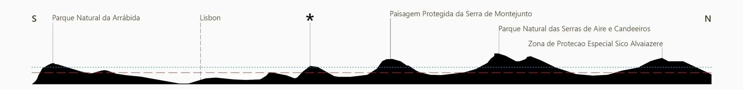
The Arruda site occupies a notable biogeographical position within central Portugal’s Atlantic karstic massifs, forming part of a chain of limestone sky islands that rise from the Lusitanian Basin, extending from Serra de Sicó near Coimbra in the north, to the Arrábida UNESCO biosphere reserve in the south. Set within steep terrain just below the summit of Serra da Carvalha, the site lies at an average elevation of 340m, close to the local orographic cloud base, receiving over 850mm average annual precipitation.
This elevated, moist, cool microclimate harbors a predominantly relict flora. North facing valleys around the summit act as refugia, while the surrounding lowlands, considerably hotter and drier, restrict upward or downward species movement between peaks along the mountain chain. As a result the area hosts numerous narrow endemics and relict tertiary and pleistocene species, alongside a mosaic of cool-temperate and Mediterranean taxa.
This mosaic directly informs the project concept. The design prioritizes the integration of existing remnants of these plant communities, including a stand of the nationally rare maple Acer monspessulanum, extensive thickets of the endemic gorse Ulex airensis, and a notable abundance of Europe’s largest orchid Barlia robertiana, while restoring degraded areas where appropriate, including the expansion of an oak woodland dominated by mature specimens of Quercus faginea subsp. broteroi.
The site is divided by an existing concrete boundary wall into the inner gardens, and the outer woodlands. Contained within the wall are the inner gardens, organised around the main house as sequence of ‘Sky Island Gardens’, proposed to interpret and celebrate the region’s exceptional floristic diversity, supported by a series of food forests created through the conversion of a highly degraded vineyard. The outer woodlands are treated as a restoration project, with the removal of existing pine and eucalyptus plantations, facilitating the recovery of the native oak woods.
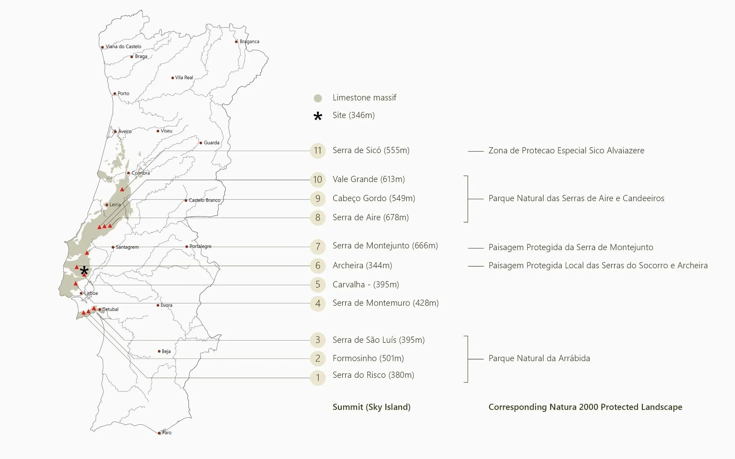
Distribution of the most prominent sky islands
North-south section of the limestone massifs that dominate the Lusitanian Basin
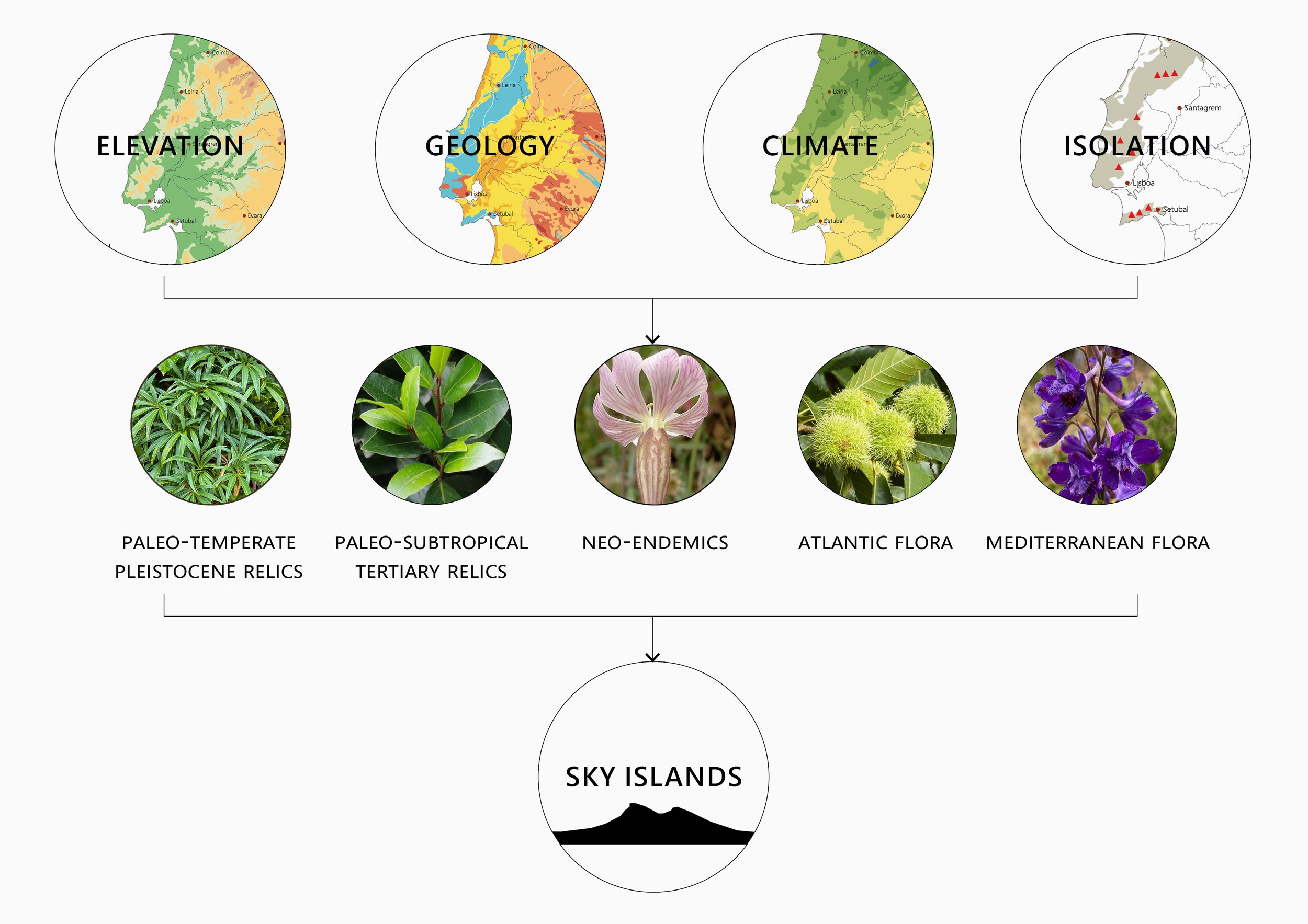
Florist composition of the sky islands
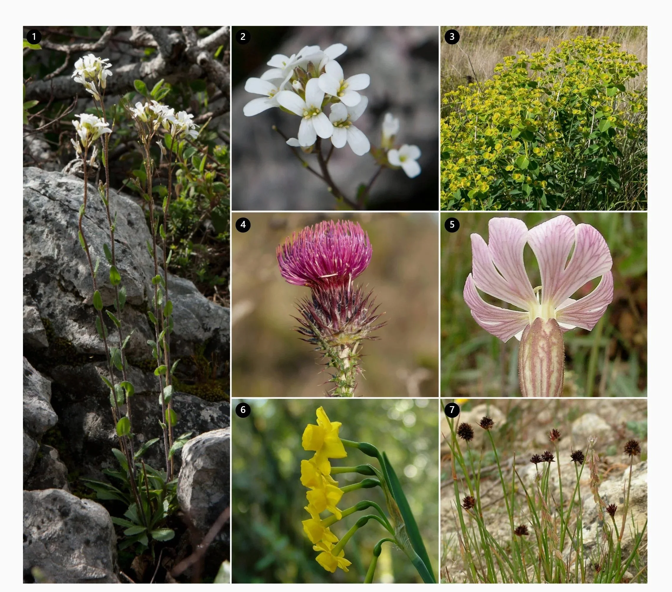
Representaive selection of endemic flora found across the sky islands
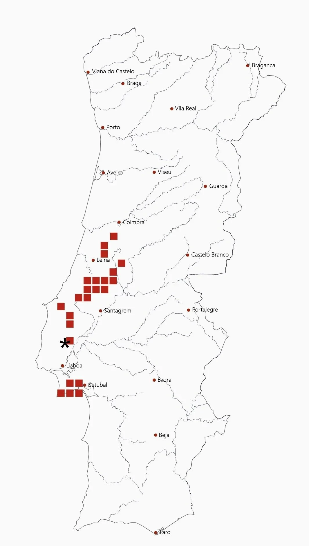
Distribution of the narrow endemic Arabis sadina
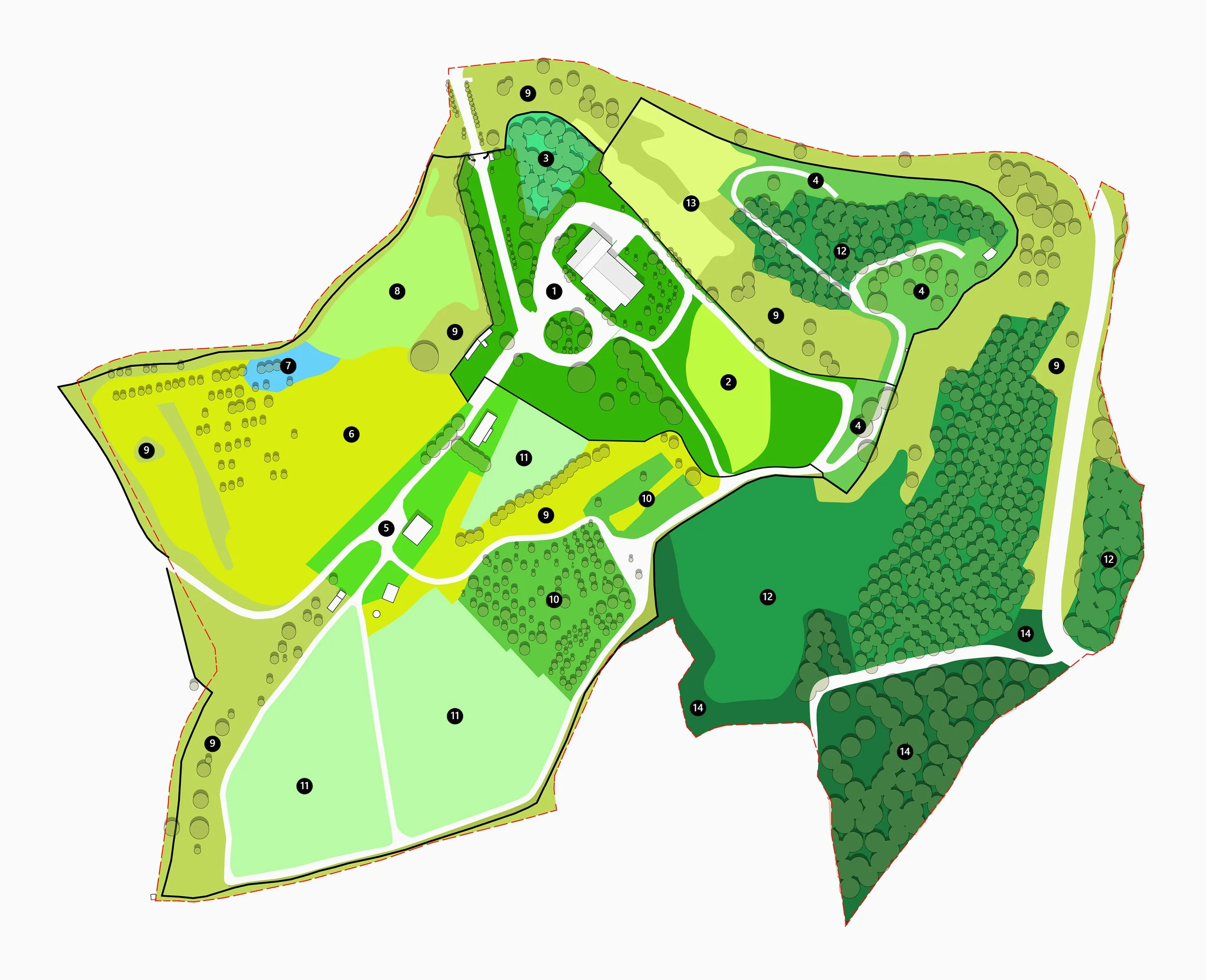
Ecological Framework Plan
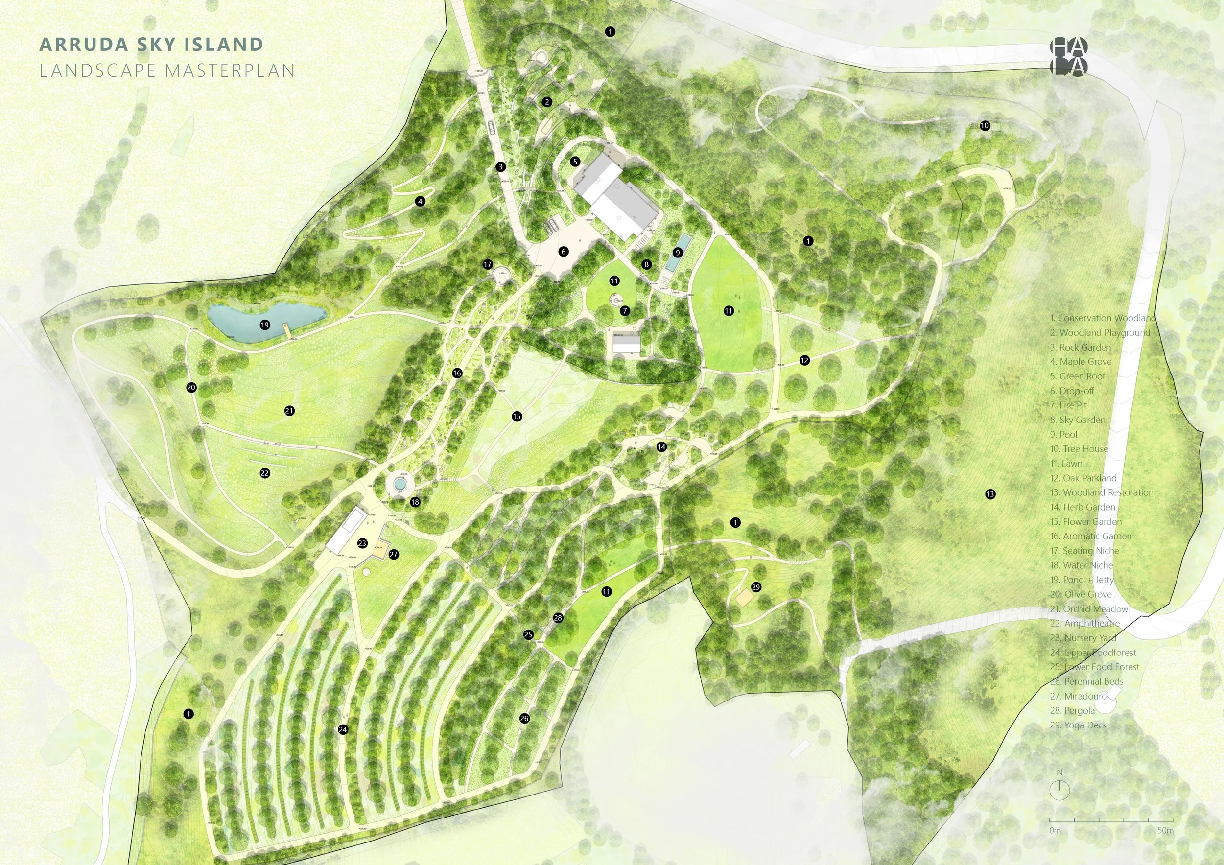
Landscape Masterplan
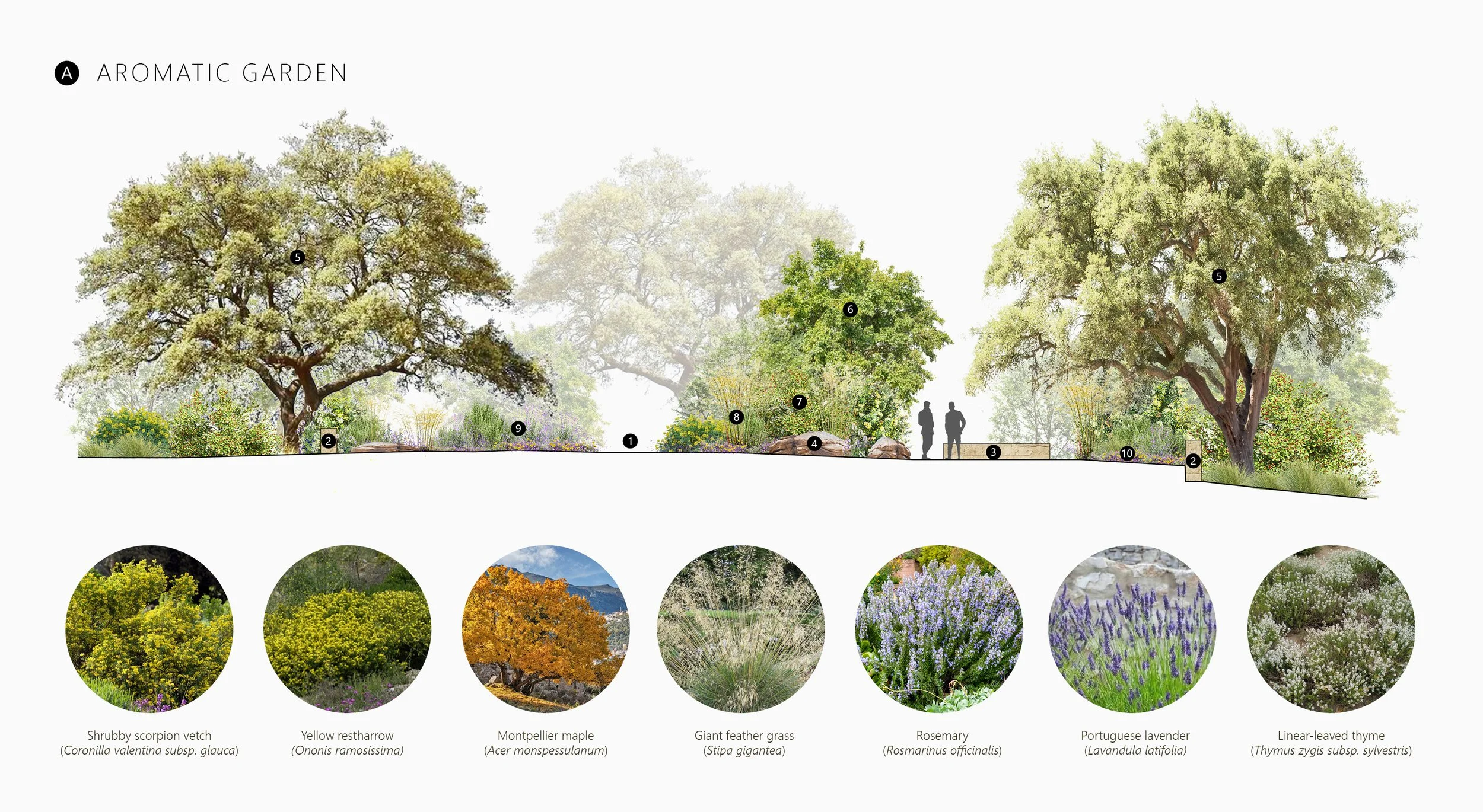
The Aromatic Garden is designed as an archetypal Mediterranean gravel garden composed of winding paths, loose dolomite boulders, reflection pools, and scrubland species appropriate for this dry, wind exposed main ridge with poorly developed marl soils. The space connects the main house and guest house to the food forest pavilion along this ridge, forming a strong north-east to south-west axis within the property. Much of the garden is enclosed by a low drystone wall composed of limestone.
Ecologically the garden functions as a extension of the existing thyme garrigue community Teucrio capitati-Thymetum sylvestris, found adjacent to the site, dominated by Thymus zygis subsp. sylvestris, Urginea maritima, and Anemone palmata, with the addition of Acer monspessulanum in the structural layer. Functionally the garden would be used for the cultivation of cut flowers and culinary aromatic native herbs.
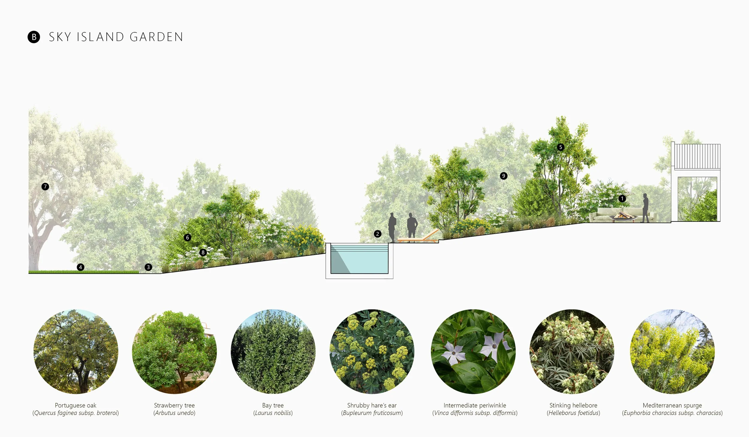
In contrast to the drier Aromatic Garden, the Sky Island Garden is conceived as a sheltered, woodland-edge environment that visually anchors the main house and guest house within the wider landscape while providing protection from the prevailing north-west winds. Its character draws from the Portuguese oak and bay woodland edge, referencing the plant communities Arisaro simorrhini–Quercetum broteroi, Leucanthemo silvatici–Cheirolophetum sempervirentis, and Vinco difformis–Lauretum nobilis. The resulting composition explores dappled shade, layered canopies, and malacophyllous evergreen foliage, creating a calm, immersive space defined by deep green tones.
The planting strategy is arranged as a matrix emerging from a dense ground layer of mat-forming herbaceous perennials and subshrubs, punctuated by larger shrubs and small trees that integrate the drop-off area, swimming pool, and dining terrace. Around the terrace and pool, the planting subtly opens, directing views eastwards across a drought-tolerant lawn to the distant lowland landscape of the Tejo valley.
One of the most characteristic features of the regional landscape is the Sloeberry Thicket, dominated by the small tree Prunus spinosa subsp. isitiioides. These thickets traditionally formed dense field boundaries, erupting into masses of cherry-like white blossoms in late winter, supporting a remarkably rich assemblage of plant species within the agricultural landscape. Much of this habitat has been lost due to the drive toward larger, mechanised fields, erasing an important structural and ecological element of the landscape. The project aims to re-establish this thicket system as a significant functional component of the property, screening an unsightly concrete boundary wall, increasing privacy, reinforcing the windbreak structure, and reconnecting fragmented patches of surrounding woodland.
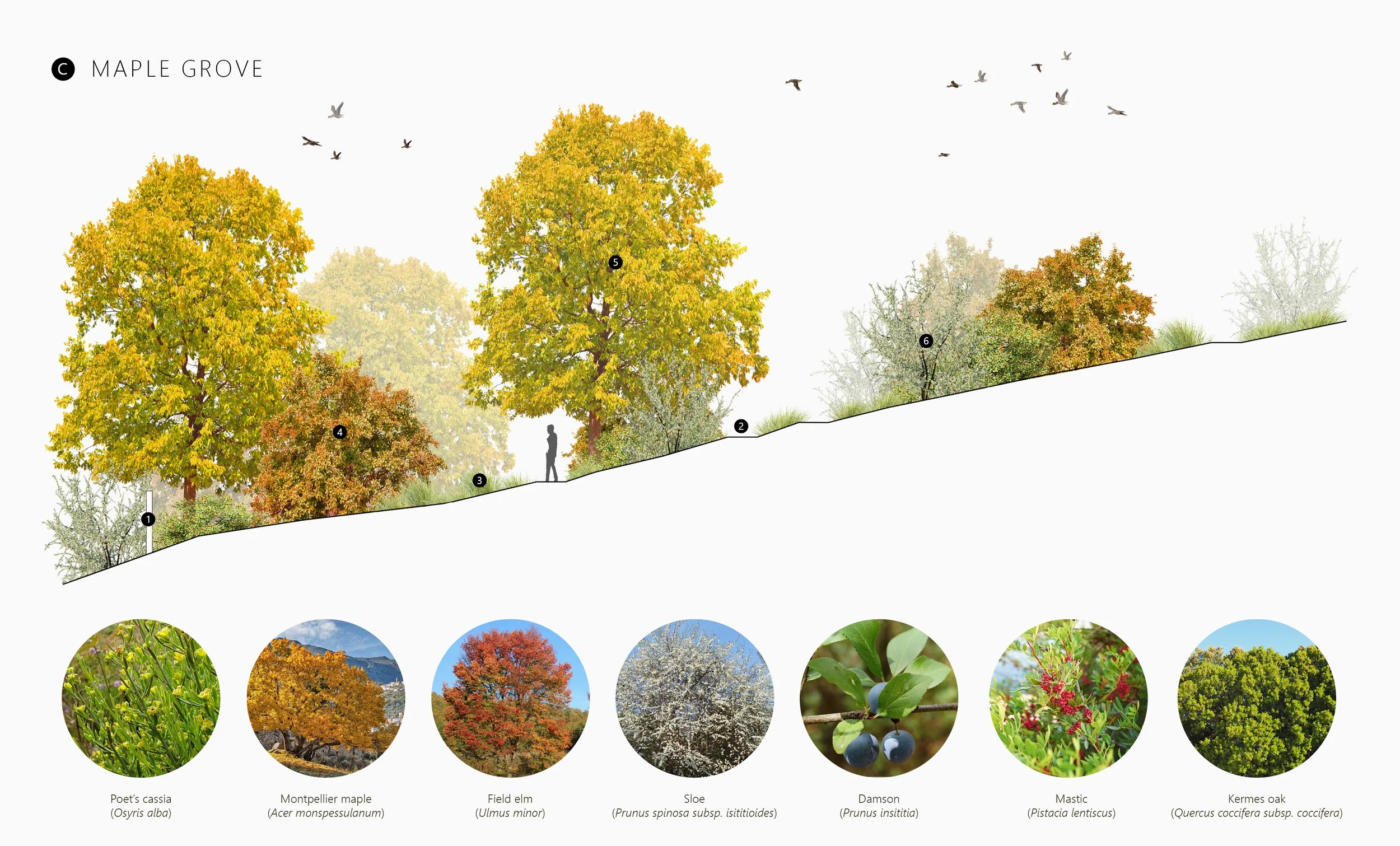
North of the Aromatic Garden and driveway, the Maple Grove descends gently towards this sloe hedge, occupying a moderately moist valley position. The unexpected discovery of a roadside stand of Acer monspessulanum, a raren species in the region, approximately 200m north-west of the property, inspired the proposal for a dedicated maple grove on site.
The proposed grove lies within a microsite that mirrors the hydromorphy and soil conditions of the existing stand, while its more northerly aspect helps moderate summer moisture deficits. Here, the grove would integrate into a mosaic of Brachypodium meadows and sloe thickets that closely resembles the habitat in which the local maples occur.
A network of gravel paths is proposed to weave through the grove, offering shifting perspectives of the maples throughout the year. The maple provides season-long interest, with grey-white bleached stems etched against the winter sky, fresh green foliage emerging with spring budbreak, abundant clusters of vivid pink samaras in late summer, and finally the soft yellowing of autumn leaves as they fall.
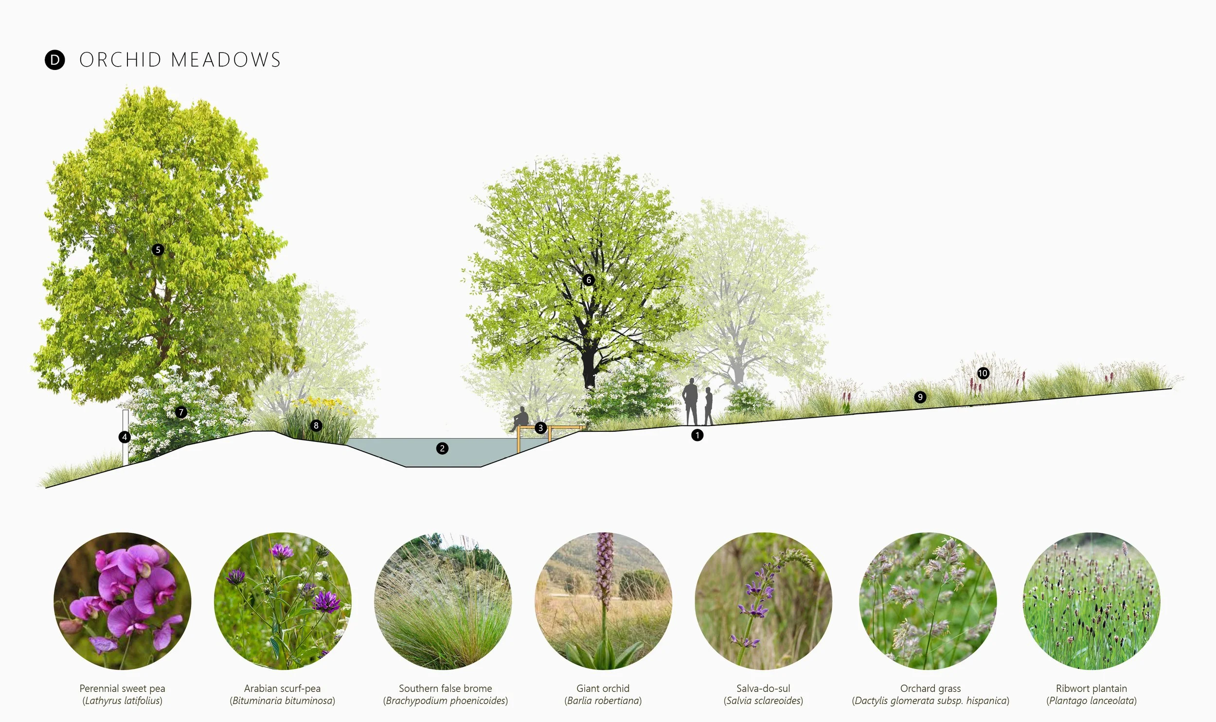
The largest landscape typology within the inner gardens is formed by the Orchid Meadows, corresponding to the plant community Phlomido lychnitidis–Brachypodietum phoenicoidis. This perennial meadow type is characterised by the evergreen bunchgrass Brachypodium phoenicoides, which provides year-round structure and shelter for a diverse array of wildflowers, particularly rhizomatous species and geophytes, including numerous orchids. Of special interest on and around the site is the remarkable abundance of Europe’s tallest orchid Barlia robertiana, which frequently reaches 90cm or more, producing striking magenta inflorescences throughout winter.
Due to eutrophication caused by historic management regimes, much of the site’s meadow flora has been impoverished, with the exception of a well-preserved section along the western boundary. The aim for these modified areas is to reduce soil fertility through targeted topsoil removal, followed by overseeding with a carefully selected species mix. Over time, orchids are expected to recolonise from the core population in the west as nutrient levels decline.
Several focal points are proposed within the meadows, including two retention ponds designed as wetland habitats surrounded by elderberry thickets, an amphitheatre overlooking the summit of Serra da Carvalha, and a Portuguese oak parkland, offering varied spatial experiences within this transforming landscape.
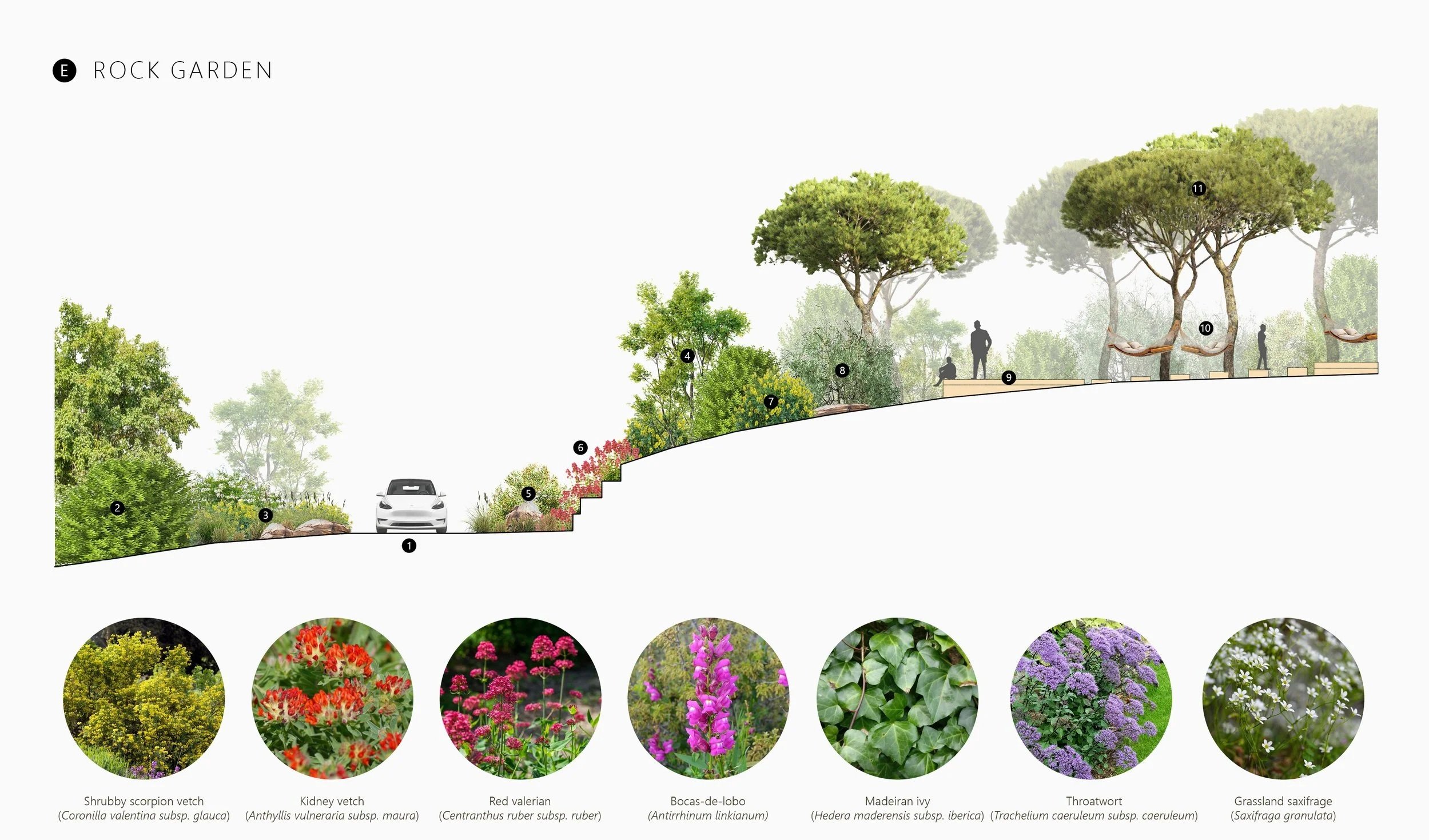
A prominent existing feature of the property is the long rock wall that retains the eastern slope of the driveway. The design response for this area is the creation of a Rock Garden, taking full advantage of the shallow rocky soils and steep topography. The existing wall running parallel to the driveway is retained and planted with a diversity of casmophytic species characteristic of the plant community Sileno longiciliae–Antirrhinetum linkiani, dominated by Centranthus ruber subsp. ruber and Antirrhinum linkianum. With their extended flowering period from early spring to late autumn, these species provide a vivid and dynamic entrance sequence throughout the year.
The garden transitions into the Woodland Playground, located on the ridge above the retaining wall. Here, three play spaces occupy the understorey of an existing, carefully thinned stone pine plantation. These spaces are linked by raised pathways constructed from sections of felled pine trunks, while the remaining removed pines are chipped for use as mulch. The play areas include a deck with a climbing net, a deck with hammocks and seating, and a raised sand pit. Shrubby planting along the western and northern edges creates a more intimate, sheltered atmosphere, integrating the playground into the surrounding woodland character.
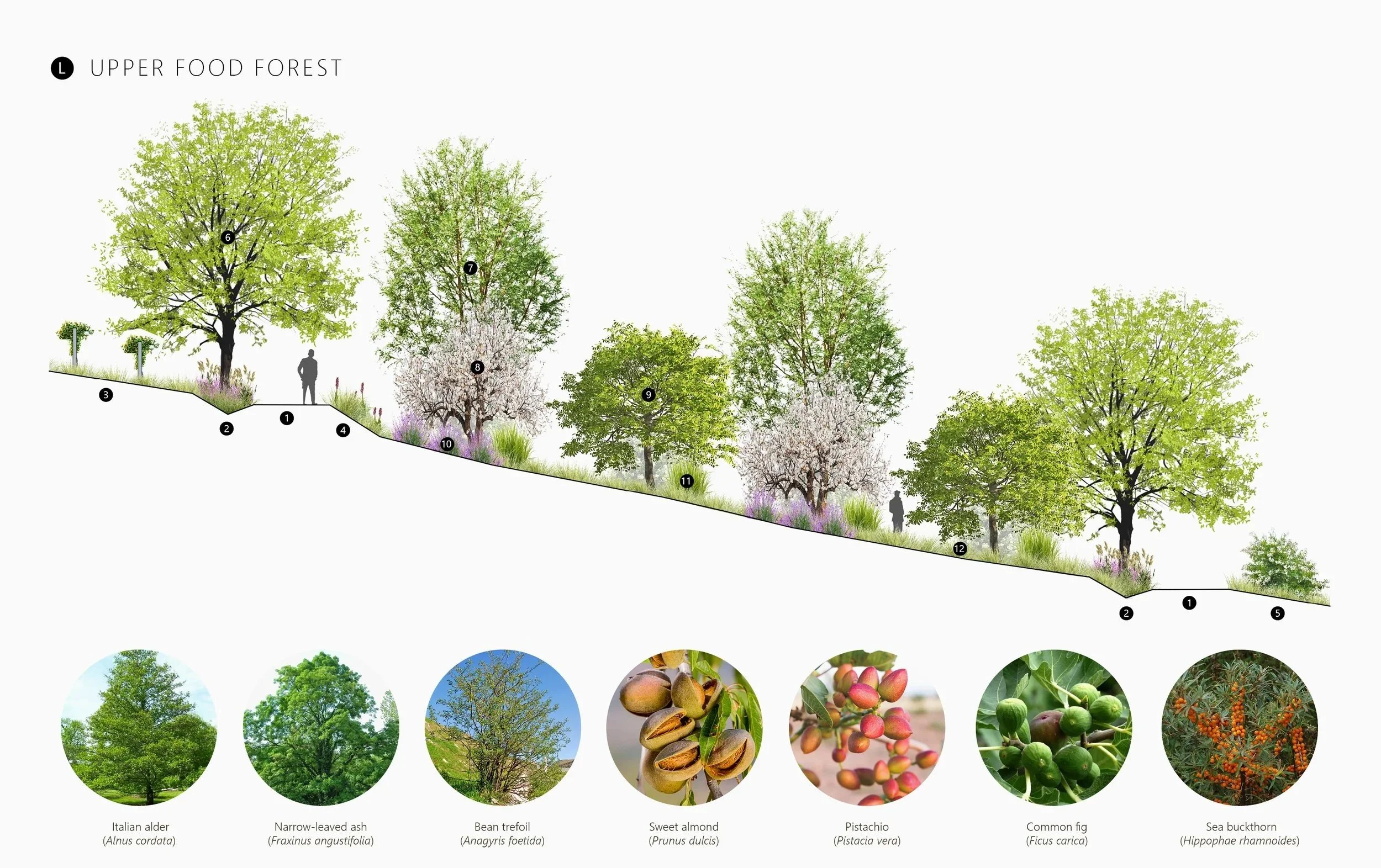
Situated on a dry, south-facing slope with nutrient-poor soils, the Upper Food Forest occupies the steeper portion of the former vineyard. Historic mismanagement has left the soils depleted and the slope highly susceptible to drought and erosion. To support the establishment of the agroforestry system, three raingardens are proposed, two upslope and one downslope, designed to capture and infiltrate surface runoff, enhance soil moisture, reduce erosion, and facilitate an increase in soil organic matter. Two new access roads are located parallel to the raingardens, improving access for management while capturing additional precipitation.
The system is organised into four long on-contour rows, each extending 150m in length. Each productive tree row is flanked on the south-facing downslope by a continuous line of vetiver grass, which functions as a nurse crop by shading young trees, reducing surface temperatures, and anchoring the soil with its extensive root system.
Trees are planted on a 4m in-row spacing, with the understorey alternating between groundcovers of woody herbs, perennial vegetables, edible shrubs, and climbing vines. The species palette is primarily modeled on the traditional limestone terrace systems of the Algarve’s Barrocal region, which feature carob, almond, pomegranate, fig, and olive. These systems share comparable soil characteristics and a similar south-facing aspect.
Between the tree rows run 4m wide alleys sown with an orchid meadow seed mix, managed with two annual cuts timed prior to harvesting and pruning operations. Species selection favors a mix of deep taprooted and mat-forming perennials together with a diversity of nitrogen-fixing legumes and bunchgrasses.
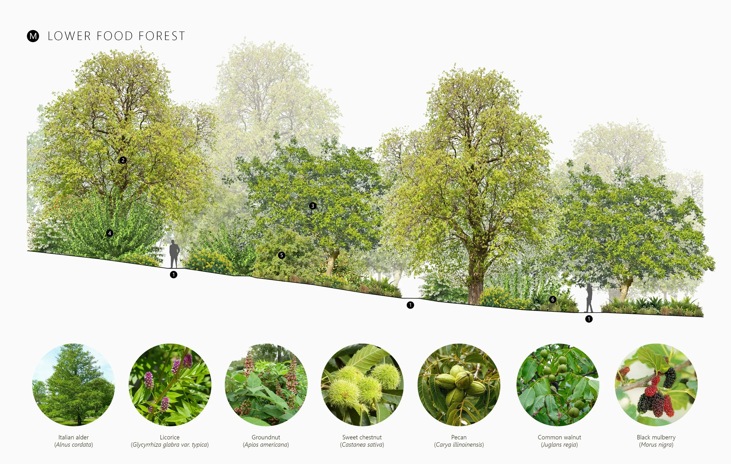
The Lower Food Forest occupies the base of the valley at the site’s keypoint, creating two distinct character zones within this section of the agroforest. Above the keypoint, where the slope is steeper, the forest is designed as a dense planting with a rich understorey of shrubs and lianas. Below the keypoint, the slope eases into gentle to flat terrain, where beds of edible herbaceous perennials establish a south-facing woodland-edge condition, capitalising on abundant light and higher soil moisture.
Tree planting is organised on a triangular grid, ensuring efficient spatial distribution. Emergent canopy species, including sweet chestnut, walnut, and pecan are spaced 13m apart, while canopy and sub-canopy trees such as black mulberry and avocado are spaced 6.5m apart. Shrubs, lianas, and groundcover plants are arranged in naturalistic clusters, responding to the geometry of the path network and the slope gradient.
Timeline 2024-27
Location Arruda dos Vinhos, Lisbon
Site area 9.3 hectares
Project Type Private residence
Architect www.pedrocarrilho.pt